


GPS NMEA Tool

คำอธิบายของGPS NMEA Tool
GPS NMEA is a small tool to view NMEA data returned by the built-in gps receiver.
It has got three views that enables to view,
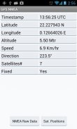
1. Summary of data which includes latitude, longitude, altitude, speed etc
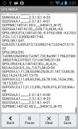
2. Shows the RAW NMEA data returned by the GPS
3. Allows to pause or save (to external media) a set of sample raw data for analysis
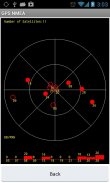
4. Show positions and the signal strength of the satellites in view
Notes: You have to enable location access for GPS to get the location data
Also when you saving data the external media may not be accessible if its has been
mounted by the user on their computer.
Please mail to the developer if anything not working or needs improvement
Thanks for visiting GPS NMEA app
</div> <div jsname="WJz9Hc" style="display:none">GPS NMEA เป็นเครื่องมือขนาดเล็กเพื่อดูข้อมูล NMEA กลับโดยในตัวรับสัญญาณ GPS
จะได้มีสามมุมมองที่ช่วยให้การดู
1 สรุปข้อมูลซึ่งรวมถึงเส้นรุ้งเส้นแวงระดับความสูง ฯลฯ ความเร็ว
2 แสดงให้เห็นถึงข้อมูล NMEA RAW กลับโดย GPS
3 ช่วยให้การหยุดชั่วคราวหรือบันทึก (สื่อภายนอก) ชุดของข้อมูลดิบตัวอย่างสำหรับการวิเคราะห์
4 ตำแหน่งการแสดงและความแรงของสัญญาณของดาวเทียมในมุมมอง
หมายเหตุ: คุณต้องเปิดใช้งานการเข้าถึงตำแหน่งสำหรับ GPS ที่จะได้รับข้อมูลสถานที่
นอกจากนี้เมื่อคุณบันทึกข้อมูลสื่อภายนอกอาจไม่สามารถเข้าถึงถ้าได้รับของ
ติดตั้งโดยผู้ใช้บนคอมพิวเตอร์ของพวกเขา
กรุณาส่งอีเมลมาให้กับนักพัฒนาหากมีสิ่งใดไม่ทำงานหรือจำเป็นต้องปรับปรุง
ขอบคุณสำหรับการเยี่ยมชม GPS NMEA App</div> <div class="show-more-end">
GPS NMEA Tool--เวอร์ชั่น1.1
(05-07-2014)
GPS NMEA Tool - ข้อมูล APK
เวอร์ชั่น APK: 1.1แพ็คเกจ: com.ppillai.gpsnmeaเวอร์ชั่นล่าสุดของGPS NMEA Tool


แอปในประเภทเดียวกัน

คุณอาจจะชอบ...


